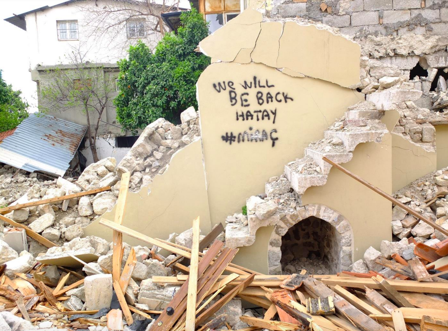
On 6th of February, Turkish people received news that left them shocked for weeks. Two massive earthquakes shook the southern provinces of the country. I remember being stuck by the TV, watching the damage escalating before my eyes. Unfortunately, everyone I know has been affected by the Turkey-Syria Earthquake in many ways, they lost their friends, classmates, co-workers and other familiar faces. It also happened during a semester break, when many students returned to their homelands to never come back. People not only lost their friends, close ones and family, but also their homes, their dearest possessions, photos, memories, the neighbourhoods they grew up in. Life was never going to be the same.
The neighbourhoods that were rich in cultural tapestry were damaged severely. For the multicultural society of Antakya, seeing their sacred and commercial spaces being destroyed was undoubtedly a traumatic experience. Mosques, Churches, Synagogues, monuments, ancient streets that were resistant for centuries or even a millennium, were all of a sudden destroyed. These monuments were a trace of their past, which was a sign that they belonged here, in Antakya.
”In Antakya, faith and life go together.”
Prof. Dr. Güliz Bilgin Altınöz
In these times of collective trauma, it’s crucial to be as transparent as possible, come up with a plan to diverge from the chaos, and take action. The nation was in a dire need of information as people were desperate to help the victims. On 4th of December, METU TAÇDAM (Middle East Technical University Centre for Research and Assessment of Historical Environment) shared their studies of post-earthquake Antakya with NIT. They reported their studies and data in detail. I must say that it was clearly presented while focusing on multiple academic areas: urban planning, engineering, archaeology, cultural studies and more. The METU TAÇDAM team carried out three expeditions to Antakya. Their case studies were wide-ranging from open air spaces to residencies. Then they discussed the results of the reports and the mistakes that had been made in the past.
Setting the Correct Methodology and Gathering Data
As a state of emergency was declared, the team had to be precise over their methodology to take the best measures. The METU team was taking a great risk since many buildings were still collapsing after the earthquake. Before their expedition the team analysed previously published literature on Antakya, and gathered data on the damaged areas via a form. And on March 23, they carried out their first field visit.
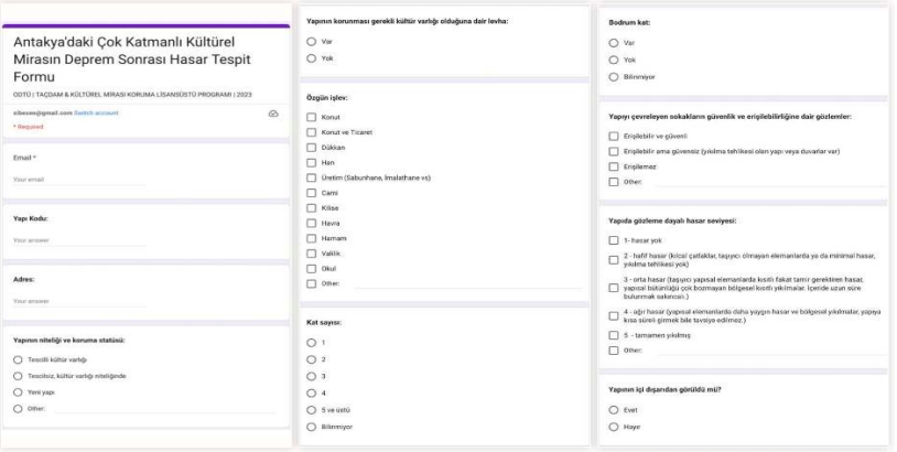
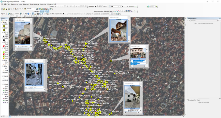
At first they documented the area with their smartphones and compared the previous data to post-earthquake pictures, but the area was severely damaged and it was impossible to identify the streets through pictures only. Luckily, the team was well-prepared. The geo-mapping system of pre-earthquake Antakya METU has created beforehand proved itself to be useful.
Assessment of Data and Field Work
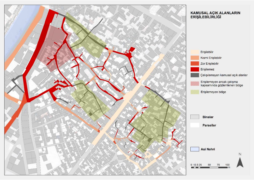
”In Antakya, faith and life go together” said Prof. Dr. Güliz Bilgin Altınöz. With such a long history, Antakya is a complicated place where different ethnic and religious communities continue to live among each other. Since there is an evolution of construction from the Greek and Roman periods, Ottoman period, French Mandate to modern times, the city has gained cultural and technological richness, but also fragilities. Due to the remnants of former settlements there are a lot of layers. Thus it is important not to jump to conclusions while making construction plans for the future, but to take each layer and fragilities into consideration. Altınöz reminded us that ”This project is not limited to touristic and historical purposes only; of course they are valuable and important but Antakya will continue to be a settlement; so infrastructure, the continuity of life and accessibility of spaces are our priorities.” Not to mention, accessing clean water, roads, a clean sewage system, and security were also noted down.
During rubble removal, urban planners and construction workers needed to be extremely careful not to repeat the mistakes of the past, to inform property owners beforehand and to take many other precautions. But a lot of rubble removal happened without precaution. The rubbles were unidentified, surviving structures and buildings got damaged during rubble removal and even demolished without notice, and there were cases of theft. Prof. Dr. Altınöz described an unfortunate case of misidentified debris, where we supposedly see a small rubble that was to be removed. However archaeologists then identified the debris as a ruin from the Roman Period. Such cases of looting were also reported on the news at the time, but the damage was done.
Yet the METU team kept their hopes high as there was so much to work on. Though when the directorate declared Antakya as a risk area, they had to make a plan B. The team then moved forward to get local support from the municipality of Antakya, local organisations and NGOs, and received funds from Cultural Emergency Response.
During their second field trip they prioritised 12 points for research, for their significance to the communities, their pre and post-earthquake situation, and the intervention process. Various technologies like laser scanning and generated drawing were effective.
Notes on Post-Earthquake Antakya
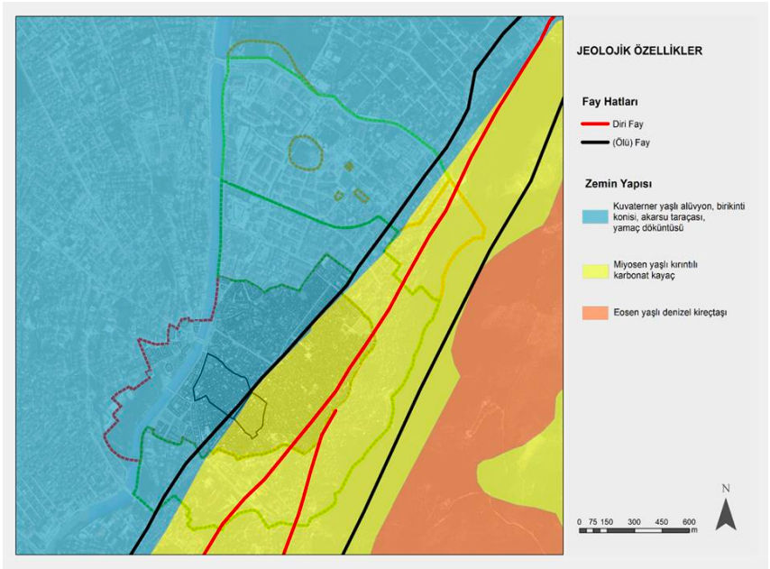
”We wanted to show our finds with proven data.” said Dr. Duygu Ergenç. She hopes that the geological maps will be useful to guide people in the future. The finds show that there are active fault lines in the middle of Antakya through Kurtuluş Highway.
The importance of Iskenderun was also pointed out by Prof. Dr. Neriman Şahin Güçhan. ” In the past, new construction materials penetrated through Iskenderun port. For this reason steel was introduced. Construction workers then thought steel would be a durable construction element, but it would only matter as long as the steel was well-bounded on the floors.” said Prof. Dr. Şahin Güçhan. Assoc. Prof. Dr. Mert Nezih Rifaioğlu from Iskenderun University exchanged local opinions; he concluded that the locals of Antakya are supportive and they trust their studies.
Turkey as a whole being an earthquake zone is indisputable. With alarming information like this sometimes one feels like they are paralysed, waiting for the disaster to happen. Thus it certainly feels good to know that there are experts from a variety of areas who strive to raise awareness, and to guide people for future steps. We wholeheartedly hope to see Antakya recover speedily and to see Antakya become a habitable city as it was in history.
The lecture is available in the link below.
- Pictures are from the report of METU TAÇDAM team. You can access the report here (in Turkish): https://tacdam.metu.edu.tr/en/system/files/kvmgm_raporu_v2_final_02062023.pdf ↩︎